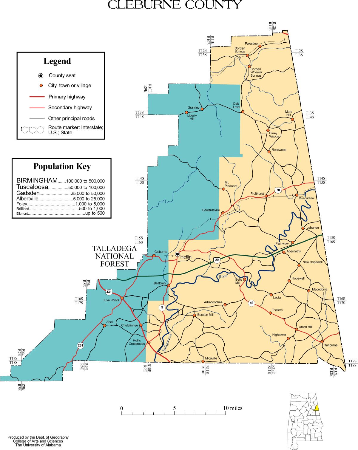
Cleburne County
Courtesy Of Alabama Maps, click to enlarge and save.
Cleburne County sits along Alabama’s eastern edge, shaped as much by movement and necessity as by formal boundaries. Created in 1866 from portions of Calhoun, Randolph, and Talladega counties, it emerged during a period of reconstruction and realignment, when communities sought local governance closer to home. The county was named for Patrick R. Cleburne, a Confederate general, reflecting the post–Civil War era in which it was formed. From the beginning, this was a place defined less by grand cities and more by families, land, and persistence.
A Brief County History
Unlike counties that grew around a single dominant industry, Cleburne County developed through small farms, timber work, and localized trade, supported by crossroads towns and rural neighborhoods. Its terrain—rolling hills, wooded ridges, and narrow valleys—shaped settlement patterns. Families clustered near creeks, fertile bottoms, and emerging roads, often remaining in the same areas for generations. As a result, land records, tax lists, and probate files here tend to tell long, continuous stories rather than abrupt booms and busts.
Heflin, the county seat, became the administrative center not because it was large, but because it was accessible. Courthouse records, deeds, and court minutes anchor much of Cleburne County research, but the real story often lives outside town limits. Unincorporated communities—places that may never have appeared on official maps—were where daily life unfolded: churches organized, schools opened and closed, and neighbors relied on one another in ways that rarely made newspapers.
For genealogists and local historians, Cleburne County rewards patience. Census records reveal slow population shifts rather than mass migration. Cemetery transcriptions and church minutes frequently preserve family connections absent from civil records. Surnames repeat across decades, sometimes across adjoining counties, underscoring how fluid county lines were compared to human relationships. To research Cleburne County well is to follow people across time and place, not just across borders.
This page is intended as a starting point, not a conclusion. From here, you can explore individual towns, rural communities, cemeteries, and historical records tied to Cleburne County. Each section opens another door—into lives lived quietly, work done steadily, and families whose stories remain written in deeds, ledgers, and memory.
County Database
The database below links available records, locations, and references associated with Cleburne County. Rather than listing
isolated documents, the goal is to connect records to places—towns, communities, and work sites—where individuals lived
and appeared in the historical record.
As additional public records and verified sources are identified, entries are expanded to reflect new connections
between people and place.
Cities & Towns
Incorporated towns provide important anchors for research. Many records reference town names even when individuals
lived outside formal city limits. Each town listed here may be expanded over time with local history, landmarks,
cemeteries, churches, schools, and industrial sites. Click the name, and you'll be redirected to a more in-depth read of that place.
-
Heflin – The county seat and administrative center, Heflin developed as a courthouse town and transportation hub, anchoring records, commerce, and civic life for the surrounding rural communities.
-
Ranburne – Located near the Georgia line, Ranburne grew as a small agricultural and railroad community, with deep family roots extending into neighboring states.
-
Fruithurst – Shaped by fruit farming, timber, and rail access, Fruithurst became a focal point for settlement and long-standing local families.
-
Edwardsville – A rural service town that supported surrounding farms and churches, Edwardsville reflects the continuity of land, kinship, and local tradition.
Unincorporated Communities & Census Designated Places
Many families lived in communities that never incorporated as towns or no longer appear on modern maps. These places
often surface in census schedules, land descriptions, church records, postal routes, and employment records.
Documenting these communities helps bridge the gap between official records and lived experience, placing families
accurately on the historical landscape. Click the name, and you'll be redirected to a more in-depth read of that place.
-
Arbacoochee – A historically significant gold-mining community in western Cleburne County, known for nineteenth-century placer and hard-rock mining along Arbacoochee Creek.
-
Borden Springs – A rural community in northeastern Cleburne County known historically for mineral springs, agricultural settlement, and long-standing family landholdings.
-
Chulafinnee – A former gold-mining community near the Tallapoosa River, significant for early mineral exploration and nineteenth-century settlement activity.
-
Muscadine – A small agricultural community near the Georgia line, characterized by farming traditions and cross-border family connections.
In-Depth Reading
Heflin
- Is the county seat of Cleburne County, Alabama, United States. Established as the center of county government following the creation of Cleburne County in the post–Civil War era, Heflin developed primarily as an administrative and transportation-oriented community rather than an industrial city.
Key Facts
- Country: United States
- State: Alabama
- County: Cleburne County
- Status: Incorporated City
- County Seat: Yes
Geographic and Administrative Context
Heflin is located in eastern Alabama near the Georgia state line and functions as the primary governmental hub for Cleburne County. As the county seat, it houses the courthouse and central county offices, making it a focal point for legal, land, probate, and court records. Its location along historic transportation corridors contributed to its selection as the seat of government and supported modest commercial growth tied to county administration.
Historical and Economic Background
Heflin’s development followed the establishment of Cleburne County in 1866. Unlike towns that grew around manufacturing or mining, Heflin’s economy was largely driven by public administration, local commerce, and services supporting surrounding rural communities. Businesses, lodging, and professional services grew in response to courthouse activity, making Heflin a practical center rather than an industrial one. This administrative role has remained central to the city’s identity.
Community and Civic Role
As the seat of county government, Heflin has long served residents from across Cleburne County for civic engagement, legal matters, and public services. Churches, schools, and civic organizations developed alongside government institutions, reinforcing the city’s role as a stabilizing presence for nearby towns and unincorporated areas. For researchers, Heflin is often the starting point for understanding countywide history and recordkeeping.
Ranburne
- Is a town in Cleburne County, Alabama, United States, situated near the Georgia state line. The community developed around agriculture and transportation routes and has long maintained close social and economic ties with neighboring areas in both Alabama and Georgia.
Key Facts
- Country: United States
- State: Alabama
- County: Cleburne County
- Status: Incorporated Town
Geographic and Administrative Context
Ranburne lies in the northeastern portion of Cleburne County, positioned near historic travel routes connecting eastern Alabama to western Georgia. Its location fostered cross-county and cross-state movement, influencing settlement patterns and family networks that extend beyond county boundaries. Municipal governance provides local services, while county authorities handle broader administrative functions.
Historical and Economic Background
The town’s growth was closely tied to farming and small-scale trade, with cotton and other agricultural products shaping early economic activity. Railroad access in the late nineteenth and early twentieth centuries further supported local commerce and movement of goods. While never a large population center, Ranburne functioned as a service and market town for nearby rural families.
Community Continuity
Ranburne is characterized by long-standing family presence and generational continuity. Churches, schools, and cemeteries reflect deep roots and relatively stable population patterns. For genealogical research, Ranburne often reveals interwoven family histories that cross county and state lines, highlighting the fluid nature of regional identity in eastern Alabama.
Fruithurst
- Is a town in Cleburne County, Alabama, United States, known historically for agricultural development, timber activity, and rail access. The community’s name reflects early fruit-growing efforts that shaped its identity and settlement history.
Key Facts
- Country: United States
- State: Alabama
- County: Cleburne County
- Status: Incorporated Town
Geographic and Administrative Context
Fruithurst is located in the southeastern portion of Cleburne County, positioned along transportation routes that historically connected agricultural producers with regional markets. Municipal governance supports local services, while county infrastructure and state routes link the town to the wider region. Surrounding lands consist largely of forested areas and rural homesteads.
Historical and Economic Background
Early development in Fruithurst emphasized fruit cultivation, particularly orchards, alongside timber harvesting and farming. Rail access played a significant role in transporting agricultural products and lumber. While these industries fluctuated over time, they established Fruithurst as a stable rural town with diversified land use rather than a single-industry economy.
Community Life and Land Use
Fruithurst’s history is closely tied to land ownership and agricultural continuity. Churches, family cemeteries, and schools serve as anchors for community identity. For researchers, land deeds, agricultural schedules, and church records often provide key insights into family movement and economic adaptation over time.
Edwardsville
- Is a town in Cleburne County, Alabama, United States, serving historically as a local service center for surrounding rural communities. Its development reflects the needs of farming families and small-scale local commerce rather than industrial expansion.
Key Facts
- Country: United States
- State: Alabama
- County: Cleburne County
- Status: Incorporated Town
Geographic and Administrative Context
Edwardsville is situated in central Cleburne County and functions as a modest municipal center within a predominantly rural landscape. Town governance provides local administration, while county authorities oversee broader services. Its location made it accessible to nearby farming communities seeking supplies, education, and religious institutions.
Historical and Economic Background
The town’s economy historically centered on agriculture and local trade. Small businesses, schools, and churches supported daily life for nearby residents. Unlike railroad or mining towns, Edwardsville’s growth was gradual and sustained, reflecting steady land use and family settlement rather than rapid population shifts.
Social and Genealogical Significance
Edwardsville exhibits strong patterns of familial continuity, with many surnames appearing repeatedly in census, land, and church records. Cemeteries and local congregations preserve much of the town’s historical record. For genealogists, Edwardsville often represents a stable point of reference within broader regional migration patterns.
Borden Springs
- Is an unincorporated community in northeastern Cleburne County, Alabama, United States. The area developed around natural mineral springs and rural agricultural settlement rather than formal town organization.
Key Facts
- Country: United States
- State: Alabama
- County: Cleburne County
- Status: Unincorporated Community
- Known for: Mineral springs and rural settlement
Geographic and Administrative Context
Borden Springs lies in the northeastern portion of Cleburne County, near the Alabama–Georgia border. As an unincorporated community, it falls under county jurisdiction for governance and public services. The surrounding landscape consists of rolling terrain and farmland, which shaped both settlement patterns and land use over time.
Historical and Economic Background
The community takes its name from nearby natural springs, which attracted early settlers seeking reliable water sources. Agriculture formed the economic foundation of the area, with small farms and homesteads dominating land ownership. Unlike incorporated towns, Borden Springs developed without a centralized commercial district, reflecting a dispersed rural population.
Community Continuity
Families in the Borden Springs area often remained on the same land for generations, resulting in strong surname continuity in census, land, and cemetery records. Churches and family burial grounds serve as primary historical anchors, making the community significant for genealogical and land-based research.
Chulafinnee
- Is an unincorporated community in western Cleburne County, Alabama, United States, historically associated with nineteenth-century gold mining activity along the Tallapoosa River and its tributaries.
Key Facts
- Country: United States
- State: Alabama
- County: Cleburne County
- Status: Unincorporated Community
- Associated activity: Gold mining
Geographic and Administrative Context
Chulafinnee is located in western Cleburne County near the Tallapoosa River, an area historically conducive to mineral exploration. As an unincorporated community, governance and public services are provided at the county level. The surrounding terrain includes river bottoms and uplands that influenced both mining and settlement patterns.
Historical and Economic Background
During the mid-nineteenth century, Chulafinnee became one of Alabama’s notable gold-mining districts. Mining camps and supporting settlements emerged rapidly, drawing workers and prospectors to the area. Although large-scale mining declined, the district left a lasting imprint on local history and land records.
Legacy and Research Significance
Today, Chulafinnee’s importance lies primarily in its historical legacy rather than ongoing industry. Mining records, land patents, and early census entries provide valuable insights into transient populations and economic experimentation. The community serves as an example of how resource-driven activity briefly reshaped settlement in Cleburne County.
Muscadine
- Is an unincorporated community in eastern Cleburne County, Alabama, United States, near the Georgia state line. The area developed primarily through agriculture and rural family settlement rather than industrial or municipal growth.
Key Facts
- Country: United States
- State: Alabama
- County: Cleburne County
- Status: Unincorporated Community
- Economic base: Agriculture
Geographic and Administrative Context
Muscadine is situated near the eastern edge of Cleburne County, close to the Alabama–Georgia border. Its location encouraged interaction and migration between neighboring counties and states. County government oversees administrative and public services, reflecting its unincorporated status.
Historical and Economic Background
The community developed around small farms and agricultural production, with land ownership forming the core of economic life. Unlike mining or railroad towns, Muscadine experienced gradual growth shaped by family settlement and farming cycles rather than rapid expansion or decline.
Genealogical Context
Muscadine’s records frequently show long-term family residence and inter-county connections. Church records, cemeteries, and land deeds are often the most reliable sources for reconstructing local history. The community’s stability makes it particularly valuable for tracing multi-generational family lines in eastern Cleburne County.
Arbacoochee
- Is a historically significant unincorporated community in western Cleburne County, Alabama, United States. The area is best known as one of Alabama’s early gold-mining districts, with activity centered along Arbacoochee Creek during the nineteenth century.
Key Facts
- Country: United States
- State: Alabama
- County: Cleburne County
- Status: Unincorporated Community
- Known for: Gold mining
- Associated waterway: Arbacoochee Creek
Geographic and Administrative Context
Arbacoochee is located in western Cleburne County near the Tallapoosa River drainage system, with Arbacoochee Creek serving as the primary geographic feature around which settlement developed. As an unincorporated community, Arbacoochee fell under county jurisdiction for governance and public services. The area’s creek bottoms and nearby uplands made it well suited for early placer mining operations and later hard-rock exploration.
Historical and Economic Background
Gold was discovered in the Arbacoochee area in the early nineteenth century, making it one of Alabama’s earliest and most productive gold districts. Mining activity included placer mining along creek beds as well as underground hard-rock operations in later years. At its height, Arbacoochee supported mining camps, support services, and transient populations drawn by the promise of mineral wealth. The district’s activity predated and paralleled more widely known gold rushes in neighboring Georgia.
As gold production declined, the population diminished, and Arbacoochee transitioned away from mining toward rural land use. Unlike incorporated mining towns that adapted into permanent municipalities, Arbacoochee’s identity remained closely tied to its mining past rather than ongoing commercial development.
Legacy and Research Significance
Today, Arbacoochee is remembered primarily for its role in Alabama’s mining history. Mining records, land patents, and early census data document both permanent settlers and transient laborers associated with the gold district. For historians and genealogists, Arbacoochee offers insight into early resource-driven settlement patterns and the short-lived communities that formed around mineral extraction in eastern Alabama.
This page is maintained as a working reference and expanded as verified, publicly released historical information
becomes available.


